


lagardesept2016

brandy
Utilisateur

Longueur
34 km

Altitude max
233 m

Dénivelé positif
749 m
Km-Effort
44 km

Altitude min
84 m

Dénivelé négatif
740 m
Boucle
Oui
Date de création :
2018-04-17 13:08:44.492
Dernière modification :
2018-04-17 13:08:44.492
--
Difficulté : Difficile

Application GPS de randonnée GRATUITE
 SityTrail
IGN / Instituts géographiques
SityTrail Plus
Le monde est à vous
À propos
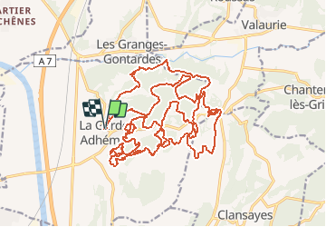
Randonnée V.T.T. de 34 km à découvrir à Auvergne-Rhône-Alpes, Drôme, La Garde-Adhémar. Cette randonnée est proposée par brandy.
Localisation
Pays :
France
Région :
Auvergne-Rhône-Alpes
Département/Province :
Drôme
Commune :
La Garde-Adhémar
Localité :
Unknown
Départ:(Dec)
Départ:(UTM)
639661 ; 4917161 (31T) N.
Commentaires